


|
By clicking Subscribe, I agree to receive advertising and other marketing messages from TGI Source under the terms of the Privacy Policy and User Agreement. |
|
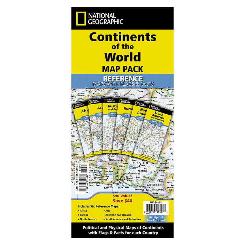
National Geographic Continents of the World Flags and Facts, folded, Map Pack Bundle, Folded: 4.25" x 9.25" ; Flat: 25.25" x 18.5"
(Contains 1 Africa; 1 Asia; 1 Australia; 1 Europe; 1 Nrth America; 1 South America)
| $49.95 |
- National Geographic's Reference maps with Flags & Facts Map Pack Bundle of Continents includes the seven continents on six waterproof tear-resistant maps.
- Each continent map includes a political map with countries and cities carefully placed for maximum readability.
- The maps are printed on waterproof, tear-resistant material which can be folded and unfolded hundreds of times making them perfect for quick reference to the news of the day or classroom use.
- Every Flags & Facts Reference map is printed on "Classroom Tough" waterproof, tear-resistant paper.
- Measures 4.25" x 9.25" folded and 25.25" x 18.5" flat
Manufacturer:
National Geographic Maps
Item:
NGMRE01021236B
UPC Code:
749717055773
Condition
New
$49.95EA
Availability
In Stock
You may be also interested
Product description
National Geographic's Reference maps with Flags & Facts Map Pack Bundle of Continents includes the seven continents on six waterproof tear-resistant maps. Each continent map includes a political map with countries and cities carefully placed for maximum readability. Each map also includes a physical map of the continent artistically representing the mountains, valley, plains, rivers, lakes and other physical features. The flags and facts for every country, enhanced with representative photographs portraying themes and regions are also included.
The maps are printed on waterproof, tear-resistant material which can be folded and unfolded hundreds of times making them perfect for quick reference to the news of the day or classroom use. The world-class cartography of National Geographic is now available in a format that will easily fit in a drawer without the need for an enormous table or wall space for a quick and easy reference source.
The Continents of the World Map Pack includes:
Africa with Flags & Facts
Asia with Flags & Facts
Australia and Oceania with Flags & Facts
Europe with Flags & Facts
North America with Flags & Facts
South America and Antarctica with Flags & Facts
Every Flags & Facts Reference map is printed on "Classroom Tough" waterproof, tear-resistant paper.
Specifications
Weight
0.75
Age Group
8+ years
Assembly Required
N
Battery Included
N
Classroom Grade
Grade 4+
Color
Multi
Country of origin
USA
Coverage Percent
Folded: 4.25" x 9.25" ; Flat: 25.25" x 18.5"
Device Types
6
Dimension Height
749717055773
Dimension Length
Maps & Map Skills
Dimension Weigth
6.00
Green Information
749717055773
Height
1.00
Length
6.00
Material
Paper
MSDS_Indicator
0.75
Operating relative humidity range
N
Post-Consumer Recycled Content Percent
Wall Reference Maps
Pre-Consumer Recycled Content Percent
9781566959391
Print technology
Y
Product Type
Maps & Map Skills
Quantity
USA
Recycled
8+ years
Total Recycled Content Percent
4905906050
Video
4.00
Width
4.00
Product ratings & Reviews
