|
By clicking Subscribe, I agree to receive advertising and other marketing messages from TGI Source under the terms of the Privacy Policy and User Agreement. |
|
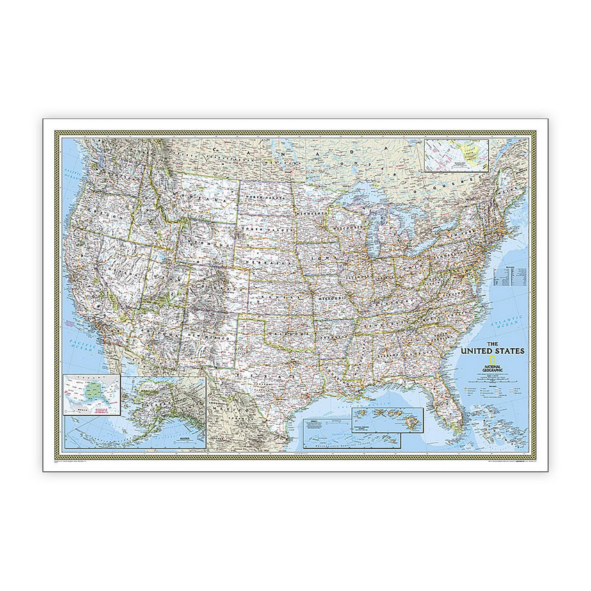
National Geographic United States Classic Map, Laminated, 43.5" x 30.5"
(Contains 1 Map)
| $29.95 |
- National Geographic's United States wall map is the standard by which other reference maps of the U.S. are measured
- Signature Classic styling with bright, easy to read color palette with blue water and colorful state borders. All 50 states with insets for Hawaiian Islands and Alaska plus inset showing relative size of Alaska
- All 50 states with insets for Hawaiian Islands and Alaska plus inset showing relative size of Alaska.
- The map is encapsulated in heavy-duty 1.6 mil laminate which makes the paper much more durable and resistant to the swelling and shrinking caused by changes in humidity.
- Measures 43.5" x 30.5"
Manufacturer:
National Geographic Maps
Item:
NGMRE00620411
UPC Code:
749717004443
Condition
New
$29.95EA
Availability
In Stock
You may be also interested
Product description
Expertly researched and designed, National Geographic's United States wall map is the standard by which other reference maps of the U.S. are measured. Signature Classic styling with bright, easy to read color palette with blue water and colorful state borders. All 50 states with insets for Hawaiian Islands and Alaska plus inset showing relative size of Alaska. Clearly defined state and country boundaries, cities, islands, national parks, and physical features. Thousands of place names carefully and artfully placed to maintain legibility in heavily populated areas. Background shows mountain ranges and valleys in subtle shaded relief with mountain ranges labeled. Major water bodies including rivers, lakes, gulfs, bays, straits, and ocean bathymetry. Transportation routes including interstate highways, major state routes, airports, waterways, canals, and ferries. The map is encapsulated in heavy-duty 1.6 mil laminate which makes the paper much more durable and resistant to the swelling and shrinking caused by changes in humidity. Laminated maps can be framed without the need for glass, so the frames can be much lighter and less expensive.
Specifications
Weight
0.38
Age Group
8+ years
Assembly Required
N
Battery Included
N
Classroom Grade
Grade 4+
Color
Multi
Country of origin
USA
Coverage Percent
43.5" x 30.5"
Device Types
1
Dimension Height
749717004443
Dimension Length
Maps & Map Skills
Dimension Weigth
37.00
Green Information
749717004443
Height
2.00
Length
37.00
Material
Paper
MSDS_Indicator
0.38
Operating relative humidity range
N
Post-Consumer Recycled Content Percent
Wall Reference Maps
Pre-Consumer Recycled Content Percent
9780792293347
Print technology
Y
Product Type
Maps & Map Skills
Quantity
USA
Recycled
8+ years
Total Recycled Content Percent
4905906024
Video
2.00
Width
2.00
Product ratings & Reviews