

|
By clicking Subscribe, I agree to receive advertising and other marketing messages from TGI Source under the terms of the Privacy Policy and User Agreement. |
|
National Geographic The Dynamic Earth, Plate Tectonics Map, Laminated, 36" x 24"
(Contains 1 Map)
| $29.95 |
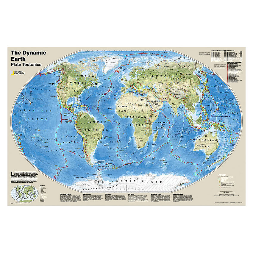
- National Geographic Dynamic Earth, Plate Tectonics Wall Map illustrates plate tectonics and features stunning bathymetry and naturally colored relief, as well as volcano and earthquake data through 2011.
- The Dynamic Earth map illustrates 17 major tectonic plates and highlights diffuse plate boundaries, convergent boundaries, spreading boundaries, fault zones, hot spots, notable earthquakes and volcanic eruptions of the 20th and 21st centuries, earthquakes with a magnitude of greater than 6.5 during the 20th and early 21st centuries, and notable volcanic eruptions during the past 10,000 years.
- The interaction of these plates causes earthquakes and volcanoes and shapes the earth's crust into mountains, valleys and deep-sea trenches.
- The map is encapsulated in heavy-duty 1.6 mil laminate which makes the paper much more durable and resistant to the swelling and shrinking caused by changes in humidity.
- Measures 36" x 24"
Manufacturer:
National Geographic Maps
Item:
NGMRE01020634
UPC Code:
749717006744
Condition
New
$29.95EA
Availability
In Stock
Product description
The Dynamic Earth map illustrates plate tectonics and features stunning bathymetry and naturally colored relief, as well as volcano and earthquake data through 2011.
Like pieces of a giant jigsaw puzzle, tectonic plates fit together to form the earth's outer shell. The interaction of these plates causes earthquakes and volcanoes and shapes the earth's crust into mountains, valleys and deep-sea trenches. The Dynamic Earth map illustrates 17 major tectonic plates and highlights diffuse plate boundaries, convergent boundaries, spreading boundaries, fault zones, hot spots, notable earthquakes and volcanic eruptions of the 20th and 21st centuries, earthquakes with a magnitude of greater than 6.5 during the 20th and early 21st centuries, and notable volcanic eruptions during the past 10,000 years.
The map is encapsulated in heavy-duty 1.6 mil laminate which makes the paper much more durable and resistant to the swelling and shrinking caused by changes in humidity. Laminated maps can be framed without the need for glass, so the frames can be much lighter and less expensive.
Specifications
Weight
0.25
Age Group
12+ years
Assembly Required
N
Battery Included
N
Classroom Grade
Grade 7+
Color
Multi
Country of origin
USA
Coverage Percent
36" x 24"
Device Types
1
Dimension Height
749717006744
Dimension Length
Maps & Map Skills
Dimension Weigth
32.00
Green Information
749717006744
Height
2.00
Length
32.00
Material
Paper
MSDS_Indicator
0.25
Operating relative humidity range
N
Post-Consumer Recycled Content Percent
Wall Reference Maps
Pre-Consumer Recycled Content Percent
9781597754569
Print technology
Y
Product Type
Maps & Map Skills
Quantity
USA
Recycled
12+ years
Total Recycled Content Percent
4905906048
Video
2.00
Width
2.00
Product ratings & Reviews