|
By clicking Subscribe, I agree to receive advertising and other marketing messages from TGI Source under the terms of the Privacy Policy and User Agreement. |
|
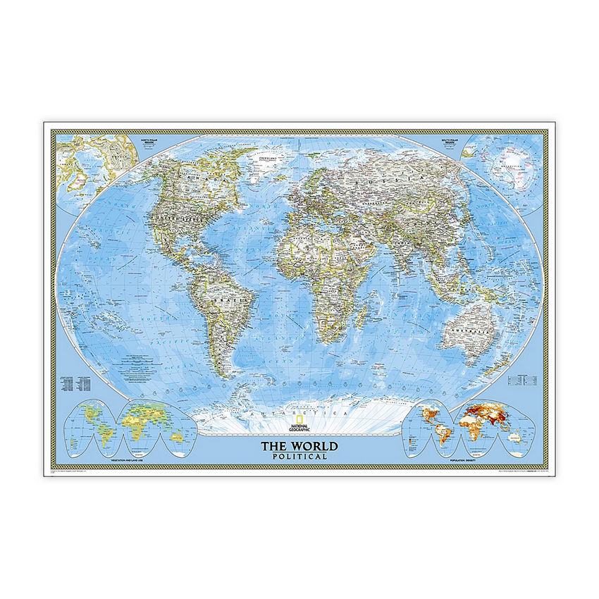
National Geographic World Classic Map, Enlarged and Laminated, 69.25" x 48"
(Contains 1 Map)
| $69.95 |
- Expertly researched and designed, National Geographic's World Wall Map is the authoritative map of the world by which other reference maps are measured.
- Signature Classic style map with bright, easy to read color palette with blue oceans and colorful borders
- Enlarged maps provide an immersive experience in any home or office environment. The exceptional cartography is even easier to appreciate at the larger size
- The map is encapsulated in heavy-duty 1.6 mil laminate which makes the paper much more durable and resistant to the swelling and shrinking caused by changes in humidity.
- Measures 69.25" x 48"
Manufacturer:
National Geographic Maps
Item:
NGMRE00622003
UPC Code:
749717004559
Condition
New
$69.95EA
Availability
In Stock
You may be also interested
Product description
Expertly researched and designed, National Geographic's World Wall Map is the authoritative map of the world by which other reference maps are measured. Signature Classic style map with bright, easy to read color palette with blue oceans and colorful borders. Background shows mountain ranges and valleys in subtle shaded relief with mountain ranges labeled. Major water bodies including rivers, lakes, glaciers, oceans, seas, gulfs, bays, straits, and bathymetry. Clearly defined international boundaries, cities, islands, airports, and physical features. Thousands of place names carefully and artfully placed to maintain legibility in heavily populated areas. Up-to-date international boundaries and territorial control reflect de facto status on the ground. Meticulously researched using multiple authoritative sources including the U.N., U.S. Board on Geographic Names, and policies of individual governments. Accurate place names use a combination of conventional English names, official national names, and standard transliterations for non-Latin alphabets. Drawn in Winkel Tripel projection with distortions minimized unlike other World maps (e.g. Greenland is shown the same size as Argentina, not South America). Corner inset maps feature vegetation, land use, population density, and north and south polar regions. Enlarged maps provide an immersive experience in any home or office environment. The exceptional cartography is even easier to appreciate at the larger size. The map is encapsulated in heavy-duty 1.6 mil laminate which makes the paper much more durable and resistant to the swelling and shrinking caused by changes in humidity. Laminated maps can be framed without the need for glass, so the frames can be much lighter and less expensive.
Specifications
Weight
0.94
Age Group
8+ years
Assembly Required
N
Battery Included
N
Classroom Grade
Grade 4+
Color
Multi
Country of origin
USA
Coverage Percent
69.25" x 48"
Device Types
1
Dimension Height
749717004559
Dimension Length
Maps & Map Skills
Dimension Weigth
53.00
Green Information
749717004559
Height
2.00
Length
53.00
Material
Paper
MSDS_Indicator
0.94
Operating relative humidity range
N
Post-Consumer Recycled Content Percent
Wall Reference Maps
Pre-Consumer Recycled Content Percent
9780792294542
Print technology
Y
Product Type
Maps & Map Skills
Quantity
USA
Recycled
8+ years
Total Recycled Content Percent
4905906030
Video
2.00
Width
2.00
Product ratings & Reviews