|
By clicking Subscribe, I agree to receive advertising and other marketing messages from TGI Source under the terms of the Privacy Policy and User Agreement. |
|
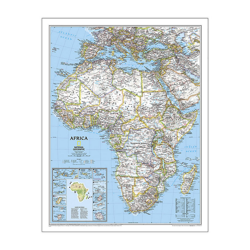
National Geographic Africa Classic Map, Laminated, 24" x 30.75"
(Contains 1 Map)
| $19.96 | Retail $24.95 |
- Expertly researched and designed, National Geographic's Africa Wall Map is the authoritative map of Asia by which other reference maps are measured.
- Signature Classic style�map with bright, easy to read color palette with blue oceans and colorful borders
- Clearly defined international boundaries, cities, islands, airports, and physical features
- The map is encapsulated in heavy-duty 1.6 mil laminate which makes the paper much more durable and resistant to the swelling and shrinking caused by changes in humidity.
- Measures 24" x 30.75"
Manufacturer:
National Geographic Maps
Item:
NGMRE00620142
UPC Code:
9780792250104
Condition
New
$19.96EA
$24.95
$24.95
Options
| Toner Cartridge |
| Network Cards |
Availability
In Stock
You may be also interested
Product description
Expertly researched and designed, National Geographic's Africa Wall Map is the authoritative map of Africa by which other reference maps are measured. Signature Classic style map with bright, easy to read color palette with blue oceans and colorful borders. Background shows mountain ranges and valleys in subtle shaded relief with mountain ranges labeled. Major water bodies including rivers, lakes, glaciers, oceans, seas, gulfs, bays, straits, and bathymetry. Clearly defined international boundaries, cities, islands, airports, and physical features. Thousands of place names carefully and artfully placed to maintain legibility in heavily populated areas. Up-to-date international boundaries and territorial control reflect de facto status on the ground. Meticulously researched using multiple authoritative sources including the United Nations and policies of individual governments. Accurate place names use a combination of conventional English names, official national names, and standard transliterations for non-Latin alphabets. Major landforms including deserts, lava fields, swamps, dry salt lakes, intermittent lakes, salt deserts, and areas below sea level. Inset maps of the 10 island nations surrounding Africa and climate and terrain topographic map of the continent.
Countries shown include: Algeria, Angola, Benin, Botswana, Burkina Faso, Burundi, Cameroon, Cape Verde, Central African Republic, Chad, Democratic Republic of the Congo, Republic of Congo, C(te d'Ivoire, Djibouti, Egypt, Equatorial Guinea, Eritrea, Ethiopia, Gabon, Gambia, Ghana, Guinea, Guinea-Bissau, Kenya, Liberia, Libya, Madagascar, Malawi, Mali, Mauritania, Morocco, Mozambique, Namibia, Niger, Nigeria, Rwanda, Senegal, Sierra Leone, Somalia, South Africa, Sudan, South Sudan, Tanzania, Togo, Tunisia, Uganda, Zambia, and Zimbabwe. The island nations shown are: Canary Islands, Madeira Islands, Comoros, Seychelles, Mauritius, Rodrigues, Reunion, Sao Tome and Principe, Bioko, and Cape Verde.
The map is encapsulated in heavy-duty 1.6 mil laminate which makes the paper much more durable and resistant to the swelling and shrinking caused by changes in humidity. Laminated maps can be framed without the need for glass, so the frames can be much lighter and less expensive.
Specifications
Weight
0.10
Age Group
14+ years
Assembly Required
N
Battery Included
N
Classroom Grade
Grade 9+
Color
Multi
Country of origin
USA
Coverage Percent
24" x 30.75"
Device Types
1
Dimension Height
9780792250104
Dimension Length
Maps & Map Skills
Dimension Weigth
25.00
Green Information
9780792250104
Height
2.00
Length
25.00
Material
Paper
MSDS_Indicator
0.10
Operating relative humidity range
N
Post-Consumer Recycled Content Percent
Wall Reference Maps
Pre-Consumer Recycled Content Percent
9780792250104
Print technology
Y
Product Type
Maps & Map Skills
Quantity
USA
Recycled
14+ years
Total Recycled Content Percent
4905000000
Video
2.00
Width
2.00
Product ratings & Reviews